What You'll Learn
Master the fundamentals of Geographic Information Systems (GIS). Learn to visualize, analyze, and interpret geographic data to gain valuable insights and make informed decisions.
Course Benefits
Industry Certification
Internationally recognized qualification
Expert Instructors
Learn from industry professionals
Dedicated Support
Assistance during and after training
Practical Skills
Apply knowledge immediately
Course Overview
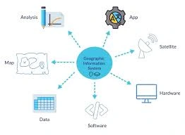
FeaturedThis course provides a comprehensive introduction to Geographic Information Systems (GIS), a powerful tool for spatial data analysis, mapping, and decision-making across various industries. Participants will gain an understanding of the fundamental concepts of GIS, including data types, spatial analysis, and map creation. Through hands-on exercises and practical examples, learners will explore how GIS can be used to visualize and analyze spatial data, solve real-world problems, and enhance decision-making processes. This course is ideal for beginners who want to build a strong foundation in GIS.
Course Duration
10 Days
Who Should Attend
- Professionals new to GIS and spatial data analysis.
- Environmental scientists, urban planners, and geographers.
- Students and researchers in geography, geology, environmental science, or related fields.
- Individuals interested in mapping and spatial data visualization.
- Decision-makers and analysts looking to incorporate spatial analysis into their workflows.
Course Impact
Organisational Impact
-
Builds foundational capacity for integrating GIS into organisational workflows and projects.
-
Enhances decision-making by enabling teams to visualize and analyze spatial data effectively.
-
Supports a wide range of applications, from environmental monitoring to urban planning and resource management.
-
Reduces reliance on external GIS specialists by empowering staff with in-house skills.
-
Provides a scalable foundation for adopting more advanced GIS and remote sensing applications.
Personal Impact
-
Equips participants with essential GIS skills for mapping, spatial analysis, and data visualization.
-
Builds confidence in applying GIS to solve real-world problems across different sectors.
-
Expands career opportunities in environmental science, planning, research, and data analysis.
-
Provides hands-on experience in creating maps and analyzing spatial datasets.
-
Empowers participants to build a strong GIS foundation, preparing them for advanced geospatial training.
Course Objectives
By the end of this course, participants will be able to:
- Understand the basic concepts and components of Geographic Information Systems (GIS).
- Identify different types of spatial data and their applications.
- Use GIS software to create, manipulate, and analyze spatial data.
- Develop skills in map design and cartographic principles.
- Perform basic spatial analysis to solve real-world problems.
- Apply GIS in various sectors such as environmental management, urban planning, and resource management.
- Interpret and communicate spatial information effectively through maps and reports.
- Understand the role of GIS in decision-making processes.
- Explore the latest trends and developments in GIS technology.
- Build a strong foundation for advanced GIS studies or professional applications.
Course Outline
Module 1: Introduction to GIS
- Definition and concepts of GIS
- Components of a GIS system
- Applications of GIS in different sectors
Module 2: Spatial Data Fundamentals
- Types of spatial data (vector, raster)
- Coordinate systems and projections
- Data acquisition and sources
Module 3: Data Management and Processing
- Importing and exporting data
- Data cleaning and preprocessing
- Spatial analysis techniques (buffering, overlay, interpolation)
Module 4: GIS Software Basics
- Introduction to popular GIS software (e.g., QGIS, ArcGIS)
- User interface and tools
- Creating and editing maps
Module 5: Spatial Data Visualization
- Map design and composition
- Creating thematic maps and charts
- Using color, symbols, and labels effectively
Module 6: Spatial Analysis Techniques
- Distance and proximity analysis
- Network analysis
- Terrain analysis
- Spatial statistics
Module 7: Web Mapping and GIS
- Introduction to web mapping technologies
- Creating web maps using GIS software
- Sharing and publishing GIS data online
Module 8: Advanced GIS Topics
- Geoprocessing scripting and automation
- Spatial decision support systems (SDSS)
- Case studies of GIS applications
Module 9: GIS in Specific Fields
- GIS for urban planning
- GIS for environmental management
- GIS for natural resource management
- GIS for transportation planning
Module 10: Project Development and Presentation
- Developing a GIS-based project
- Data collection and analysis
- Map creation and presentation
- Project report writing
Prerequisites
Course Administration Details
Customized Training
This training can be tailored to your institution needs and delivered at a location of your choice upon request.
Requirements
Participants need to be proficient in English.
Training Fee
The fee covers tuition, training materials, refreshments, lunch, and study visits. Participants are responsible for their own travel, visa, insurance, and personal expenses.
Certification
Upon successful completion of this course, participants will be issued with a certificate from Ideal Workplace Solutions certified by the National Industrial Training Authority (NITA) under License NO: NITA/TRN/2734.
Accommodation
Accommodation can be arranged upon request. Contact via email for reservations.
Payment
Payment should be made before the training starts, with proof of payment sent to outreach@idealworkplacesolutions.org.
For further inquiries, please contact us on details below:
Email: outreach@idealworkplacesolutions.org
Mobile: +254759708394
Register for the Course
Select a date and location that works for you.
In-Person Training Schedules
January 2026
| Date | Days | Venue | Fee (VAT Incl.) | Register |
|---|---|---|---|---|
| 5 Jan - 16 Jan 2026 | 10 days | Nairobi, Kenya | KES 198,000 | USD 2,800 | Enroll Now |
| 5 Jan - 16 Jan 2026 | 10 days | Cape Town, South Africa | USD 7,500 | Enroll Now |
| 5 Jan - 16 Jan 2026 | 10 days | Dubai, United Arabs Emirates | USD 8,000 | Enroll Now |
| 5 Jan - 16 Jan 2026 | 10 days | Zanzibar, Tanzania | USD 4,400 | Enroll Now |
| 12 Jan - 23 Jan 2026 | 10 days | Mombasa, Kenya | KES 230,000 | USD 3,000 | Enroll Now |
| 12 Jan - 23 Jan 2026 | 10 days | Kigali, Rwanda | USD 3,800 | Enroll Now |
| 12 Jan - 23 Jan 2026 | 10 days | Accra, Ghana | USD 7,200 | Enroll Now |
| 12 Jan - 23 Jan 2026 | 10 days | Kampala, Uganda | USD 3,800 | Enroll Now |
| 19 Jan - 30 Jan 2026 | 10 days | Dar es Salaam, Tanzania | USD 4,300 | Enroll Now |
| 19 Jan - 30 Jan 2026 | 10 days | Johannesburg, South Africa | USD 6,500 | Enroll Now |
| 19 Jan - 30 Jan 2026 | 10 days | Nakuru, Kenya | KES 210,000 | USD 2,800 | Enroll Now |
| 19 Jan - 30 Jan 2026 | 10 days | Dakar, Senegal | USD 6,000 | Enroll Now |
| 26 Jan - 6 Feb 2026 | 10 days | Pretoria, South Africa | USD 6,300 | Enroll Now |
| 26 Jan - 6 Feb 2026 | 10 days | Kisumu, Kenya | KES 210,000 | USD 3,000 | Enroll Now |
| 26 Jan - 6 Feb 2026 | 10 days | Naivasha, Kenya | KES 210,000 | USD 2,800 | Enroll Now |
| 26 Jan - 6 Feb 2026 | 10 days | Arusha, Tanzania | USD 4,300 | Enroll Now |
USD 3,000
USD 2,800
Request Custom Training
We offer customized training solutions tailored to your organization's specific needs:
- Training at your preferred location
- Customized content to address your specific challenges
- Flexible scheduling to accommodate your team
- Cost-effective solution for training multiple employees
Early-bird Offer
Special pricing ends in:
Recent Activity
Additional Options
Customize your training experienceFrequently Asked Questions
Find answers to common questions about this course
You May Also Be Interested In
Explore more courses in this category
 Intermediate
Training on Field GIS & Mobile Data Collection (Survey123, FieldMaps & ODK)
Learn how to design, deploy, and manage mobile data collection systems using Sur...
 Advanced
Training on Spatial Data Collection and Management
Master spatial data collection and management. Learn to collect, store, and mana...
 Intermediate
Training on GIS Mapping and Spatial Analysis for Energy
Gain practical skills in using GIS for energy planning, renewable resource mappi...
 Intermediate
Training on GIS and Remote Sensing for Climate Change Impact Analysis and Adaptation
Build practical skills in using spatial and satellite data to support climate re...
Intermediate
Training on Field GIS & Mobile Data Collection (Survey123, FieldMaps & ODK)
Learn how to design, deploy, and manage mobile data collection systems using Sur...
Advanced
Training on Spatial Data Collection and Management
Master spatial data collection and management. Learn to collect, store, and mana...
Intermediate
Training on GIS Mapping and Spatial Analysis for Energy
Gain practical skills in using GIS for energy planning, renewable resource mappi...
Intermediate
Training on GIS and Remote Sensing for Climate Change Impact Analysis and Adaptation
Build practical skills in using spatial and satellite data to support climate re...
Training on Introduction to Geographic Information Systems (GIS)
Next class starts 5 Jan 2026

Subscribe to our Weekly Newsletter!
Get updates on the latest posts and more from Ideal Workplace Solutions straight to your inbox.
About Us
Take your career to the next level with our industry-leading training programs. Designed to build skills, boost confidence and drive success, we empower professionals like you to excel in your current role or explore new opportunities.
Quick Links