What You'll Learn
Course Benefits
Industry Certification
Internationally recognized qualification
Expert Instructors
Learn from industry professionals
Dedicated Support
Assistance during and after training
Practical Skills
Apply knowledge immediately
Course Overview
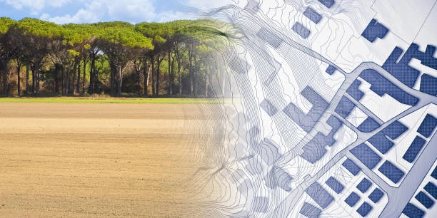
FeaturedThis course provides participants with knowledge and practical skills to use GIS and remote sensing tools for analyzing land cover and detecting land use changes. It focuses on spatial data acquisition, image processing, classification techniques, and change detection methods to support environmental monitoring, urban planning, agriculture, and natural resource management. Participants will also gain hands-on experience using leading GIS and remote sensing software.
Duration
5 Days
Who Should Attend
-
Environmental scientists and ecologists
-
Urban and regional planners
-
GIS and remote sensing professionals
-
Researchers and academicians
-
Policy makers in land management and natural resources
-
NGO and development project staff
Course Impact
Organizational Impact
-
Improved capacity for land monitoring and planning
-
Evidence-based decision-making for land use policies
-
Enhanced ability to track environmental and urban changes
-
Integration of GIS and remote sensing in development projects
Individual Impact
-
Hands-on skills in satellite image analysis and GIS tools
-
Ability to conduct land cover classification and change detection
-
Enhanced competence in applying spatial data for decision support
-
Stronger technical knowledge for research and professional work
Course Objectives
By the end of the training, participants will be able to:
-
Understand concepts of land cover and land change analysis
-
Acquire and preprocess remote sensing data for analysis
-
Apply classification techniques for land cover mapping
-
Conduct change detection using multi-temporal imagery
-
Integrate GIS and remote sensing outputs into reports and decision-making
Course Outline
Module 1: Introduction to GIS, Remote Sensing, and Land Cover Concepts
-
Basics of GIS and remote sensing
-
Importance of land cover/land use analysis
-
Data sources: satellites, aerial imagery, UAVs
Module 2: Data Acquisition and Preprocessing
-
Remote sensing data types and resolution
-
Image preprocessing: correction, enhancement
-
Practical: Downloading and preparing satellite data
Module 3: Land Cover Classification Methods
-
Supervised and unsupervised classification
-
Accuracy assessment and validation
-
Practical: Land cover mapping with sample datasets
Module 4: Land Change Detection Techniques
-
Multi-temporal image analysis
-
Post-classification comparison and change vector analysis
-
Case study: Urban expansion monitoring
Module 5: Applications, Reporting, and Policy Implications
-
Integrating GIS and RS outputs for planning and decision-making
-
Case studies in agriculture, forestry, and urban planning
-
Practical: Preparing maps and reports for stakeholders
Prerequisites
Course Administration Details
Customized Training
This training can be tailored to your institution needs and delivered at a location of your choice upon request.
Requirements
Participants need to be proficient in English.
Training Fee
The fee covers tuition, training materials, refreshments, lunch, and study visits. Participants are responsible for their own travel, visa, insurance, and personal expenses.
Certification
Upon successful completion of this course, participants will be issued with a certificate from Ideal Workplace Solutions certified by the National Industrial Training Authority (NITA) under License NO: NITA/TRN/2734.
Accommodation
Accommodation can be arranged upon request. Contact via email for reservations.
Payment
Payment should be made before the training starts, with proof of payment sent to outreach@idealworkplacesolutions.org.
For further inquiries, please contact us on details below:
Email: outreach@idealworkplacesolutions.org
Mobile: +254759708394
Register for the Course
Select a date and location that works for you.
In-Person Training Schedules
January 2026
| Date | Days | Venue | Fee (VAT Incl.) | Register |
|---|---|---|---|---|
| 5 Jan - 9 Jan 2026 | 5 days | Nairobi, Kenya | KES 99,000 | USD 1,400 | Enroll Now |
| 5 Jan - 9 Jan 2026 | 5 days | Cape Town, South Africa | USD 3,500 | Enroll Now |
| 5 Jan - 9 Jan 2026 | 5 days | Dubai, United Arabs Emirates | USD 4,000 | Enroll Now |
| 5 Jan - 9 Jan 2026 | 5 days | Zanzibar, Tanzania | USD 2,200 | Enroll Now |
| 12 Jan - 16 Jan 2026 | 5 days | Mombasa, Kenya | KES 115,000 | USD 1,500 | Enroll Now |
| 12 Jan - 16 Jan 2026 | 5 days | Kigali, Rwanda | USD 1,800 | Enroll Now |
| 12 Jan - 16 Jan 2026 | 5 days | Accra, Ghana | USD 5,950 | Enroll Now |
| 12 Jan - 16 Jan 2026 | 5 days | Kampala, Uganda | USD 2,200 | Enroll Now |
| 19 Jan - 23 Jan 2026 | 5 days | Dar es Salaam, Tanzania | USD 2,000 | Enroll Now |
| 19 Jan - 23 Jan 2026 | 5 days | Johannesburg, South Africa | USD 3,100 | Enroll Now |
| 19 Jan - 23 Jan 2026 | 5 days | Nakuru, Kenya | KES 105,000 | USD 1,400 | Enroll Now |
| 19 Jan - 23 Jan 2026 | 5 days | Dakar, Senegal | USD 3,500 | Enroll Now |
| 26 Jan - 30 Jan 2026 | 5 days | Pretoria, South Africa | USD 3,100 | Enroll Now |
| 26 Jan - 30 Jan 2026 | 5 days | Kisumu, Kenya | KES 105,000 | USD 1,500 | Enroll Now |
| 26 Jan - 30 Jan 2026 | 5 days | Naivasha, Kenya | KES 105,000 | USD 1,400 | Enroll Now |
| 26 Jan - 30 Jan 2026 | 5 days | Arusha, Tanzania | USD 2,000 | Enroll Now |
USD 1,400
Request Custom Training
We offer customized training solutions tailored to your organization's specific needs:
- Training at your preferred location
- Customized content to address your specific challenges
- Flexible scheduling to accommodate your team
- Cost-effective solution for training multiple employees
Early-bird Offer
Special pricing ends in:
Recent Activity
Additional Options
Customize your training experienceFrequently Asked Questions
Find answers to common questions about this course
You May Also Be Interested In
Explore more courses in this category
 Intermediate
Training on Remote Sensing for Environmental Monitoring
Master remote sensing for environmental monitoring. Learn to analyze satellite a...
 Intermediate
Training on Introduction to LiDAR and 3D Mapping
Master LiDAR and 3D mapping. Learn to capture, process, and analyze 3D point clo...
 Intermediate
Training on GIS for Local Government
Learn how to apply GIS for urban planning, infrastructure management, environmen...
 Advanced
Training on Geospatial Data Analysis with R
Master geospatial data analysis with R. Learn to analyze spatial data, create ma...
Intermediate
Training on Remote Sensing for Environmental Monitoring
Master remote sensing for environmental monitoring. Learn to analyze satellite a...
Intermediate
Training on Introduction to LiDAR and 3D Mapping
Master LiDAR and 3D mapping. Learn to capture, process, and analyze 3D point clo...
Intermediate
Training on GIS for Local Government
Learn how to apply GIS for urban planning, infrastructure management, environmen...
Advanced
Training on Geospatial Data Analysis with R
Master geospatial data analysis with R. Learn to analyze spatial data, create ma...
Training on GIS and Remote Sensing in Land Cover, Land Change Analysis
Next class starts 5 Jan 2026

Subscribe to our Weekly Newsletter!
Get updates on the latest posts and more from Ideal Workplace Solutions straight to your inbox.
About Us
Take your career to the next level with our industry-leading training programs. Designed to build skills, boost confidence and drive success, we empower professionals like you to excel in your current role or explore new opportunities.
Quick Links